THURSDAY, 20 JUNE 2019
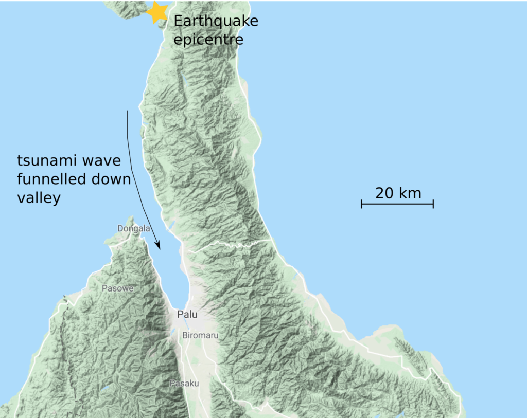
On 28th September 2018 at around 3pm local time, the residents of the city of Palu, Indonesia felt an earthquake of magnitude 6.1. Damage to several buildings was sustained, ten people were injured, and at least one person was killed.Three hours later, an earthquake ten times larger hit Palu, and this time the consequences were more severe. The magnitude 7.5 mainshock levelled many more buildings, killing or injuring those inside. Three minutes later, a 6m tsunami hit, destroying most things in its path, and carrying the debris on to generate more destruction. The death toll is uncertain, but sits above 1300 in Palu alone.
This is a familiar story from this region of the world. The infamous 2004 Boxing Day Tsunami in Sumatra, which killed over 200,000 people, is another example of this kind of tragedy. What can be done to prevent these kinds of disasters from occurring? Nothing. The tectonic forces driving these motions are too large to think about interfering with. However, hope is not lost. By studying earthquakes and the lithosphere, events like these can be predicted, prepared for, and overcome.
Tsunamis: An inevitable wave of destruction?
A success story here is from an island near Sumatra called Simeulue, also affected by the Boxing Day Tsunami. Unlike those on Sumatra, the inhabitants of Simeulue had an oral history, which spoke of an earthquake which happened in 1907 that produced a tsunami similar to that in 2004. Therefore, when they felt the earthquake and saw the sea recede, the inhabitants of Simeulue knew to get to high ground and avoid the tsunami. As a result, on an island of 75,000 people, only 7 were killed. Compare this with the 200,000 deaths in Northern Sumatra.
So, what links earthquakes and tsunamis, and how do we know if an earthquake will cause a tsunami? I spoke to Professor James Jackson, the Professor of Active Tectonics at the Earth Sciences Department in Cambridge to find out.
“Tsunamis happen because you displace the seafloor. Normally what happens with big tsunamis like Sumatra [in 2004] and Japan [in 2011], is the seafloor is moved upward very quickly by a thrust event. The water has nowhere to go, so the sea surface is displaced, and a wave flows away. In Palu [Sulawesi] the seafloor moved horizontally rather than vertically,” Prof Jackson explains. This means it’s difficult to explain the tsunami by the seafloor moving. However, the earthquake happened on the edge of a continental shelf. This could have generated an “underwater landslide” which have been known to generate very big waves. An example of this happened off the coast of Newfoundland in 1929. In this case, the underwater landslide could be monitored, as it cut the transatlantic submarine cables!
In Palu, the geography was particularly unfortunate. The valley in which Palu sits opens towards the origin of the tsunami, so the wave was effectively funnelled inland and the energy wasn’t allowed to spread sideways. By contrast, in the neighbouring island of Borneo, 150 km away, the effects of the wave were not felt as much.
Now we can link earthquakes to tsunamis, the next questions to consider are: where do earthquakes happen, how often do they happen, how big are they, and do they have tsunamigenic mechanisms?
Predicting earthquakes to reduce the magnitude of impact
Earthquake prediction down to the minute, hour or even year is something of which we are not yet capable. But sometimes science can help us say where we expect earthquakes to be likely soon.
An example of this is the 1989 Loma Prieta earthquake, which occurred along the San Andreas Fault in California. We obviously expect earthquakes here, but what was special about Loma Prieta was that scientists had already been expecting an earthquake along that segment of fault. A ‘seismic gap’ had been observed: a region of little or no seismicity, surrounded by regions of micro-seismicity. The micro-seismicity was too small to be felt on land, and so was no danger. In terms of stress and strain, the seismic gap was effectively locked, and accumulating tension, while the micro-seismic region was releasing this tension over a long period of time. Therefore, at some point, the fault around Loma Prieta was bound to build up so much tension that it snapped, releasing all the energy it had accumulated very quickly in a large earthquake.
Now, how can we tell how often earthquakes might happen? Studies have found that, as one might expect, earthquakes operate in cycles with certain repeat times. This is because large earthquakes represent a gradual accumulation of strain, which is then released suddenly in a large earthquake. Following this, there is some slow post-seismic deformation where subsidence or uplift happens on a monthly/yearly timescale, followed by accumulation of more strain, and so on. This is called the Earthquake Cycle.
One way to predict future earthquake frequency is by looking into the past. The historical record can be very useful to seismologists. Earthquakes are often quite extreme and unexpected events, so historians are bound to write them down.
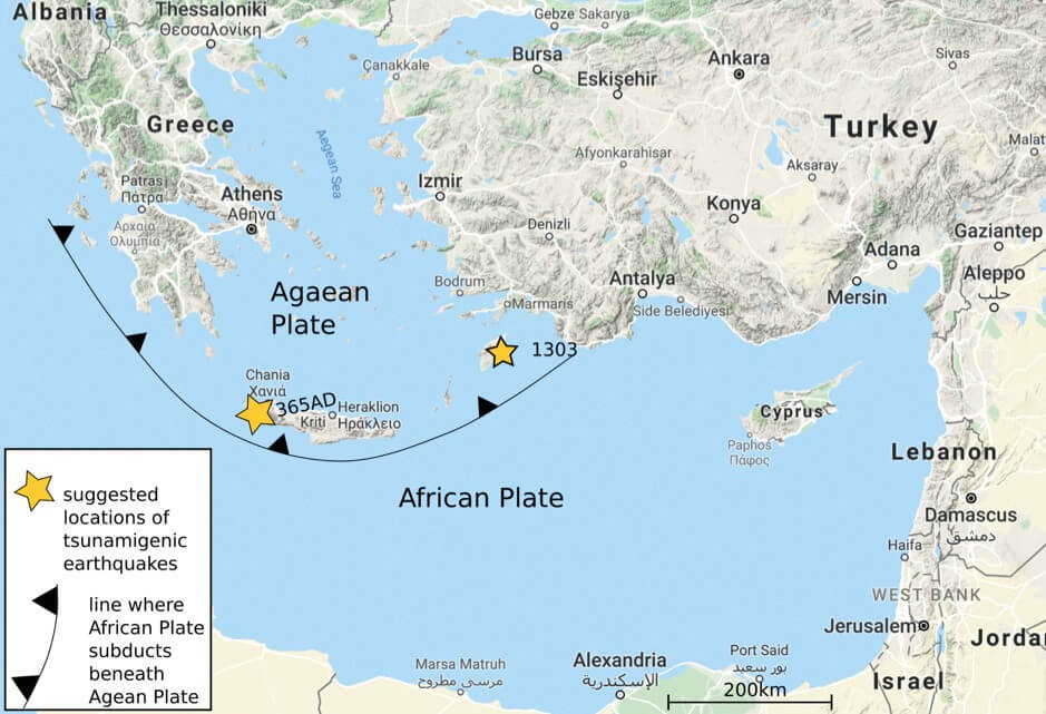
In 365 AD, historical records speak of an earthquake and tsunami which devastated part of the Egyptian city of Alexandria, and various other ancient cities around the Mediterranean. Other similar events are noted at 551 AD and 1303 AD. The cause for these events have all been quite unclear, however, as they are all historical; we have no record of these earthquakes using seismometers. How then do we figure out the mechanisms and repeat times and assess the hazard in the Mediterranean?
The Mediterranean has a lot on its plate
"If this suggestion is true, we can expect earthquakes of this kind approximately every 800 years in the Mediterranean. The last event was in Rhodes in 1303AD. Therefore, we may be due another tsunamigenic earthquake soon"
In the late 2000s researchers from Cambridge set out to figure out whether the 365 AD earthquake and tsunami could have originated off the coast of Crete on the Hellenic Subduction zone, where the African Plate is subducting beneath the Aegean Plate. But how does one determine whether slip occurred on an underwater fault thousands of years ago?
In this study, they used shoreline uplift in Crete, recorded by wave-cut notches into the uplifted shoreline. This could be dated using 14C dating on remains of corals which were alive when the shoreline was lower. They found that most of the observed uplift occurred around 365 AD plus or minus a few decades. After this, they were able to use the spatial distribution of uplift to work out the location of the slipping fault. To determine repeat time, the convergence rate of the two plates (measured by a network of high-accuracy GPS stations) could be combined with knowledge of how this fault accumulates energy. Their answer was 6000 years repeat time on this fault. Not a major hazard for the next few thousand years.
However, these kind of earthquakes are suggested to occur all along the Hellenic Subduction Zone, and this is just one point on that line. If this suggestion is true, we can expect earthquakes of this kind approximately every 800 years in the Mediterranean. The last event was in Rhodes in 1303AD. Therefore, we may be due another tsunamigenic earthquake soon.
This is a sobering message, but there is some hope of mitigating the impact of these disasters. Through education of tsunami protocol, lives can be saved. The example from the island of Simeulue shows this. Furthermore, research into tectonics around the world can help us identify regions where risk is high, and target education and infrastructural preparations at these areas.
Figures by Ben Johnson; maps from Google Maps