THURSDAY, 23 NOVEMBER 2017
BlueSci takes an inside look at The Polar Museum’s recent exhibition
The Polar Museum, on Cambridge’s Lensfield Road, is currently showing an exhibition on the town of Uumannaq, Greenland and the research being carried out by the attached Scott Polar Research Institute (SPRI) on the surrounding glaciers. BlueSci correspondent Seán Herron was lucky enough to receive a tour of the exhibition from Tom Chudley, one of the researchers who was in Greenland this year. He discusses the experience below, and explains why he thinks anyone who has the chance should go have a look!
It was a cold day, fittingly, as I cycled South and onto the Lensfield road to reach the Polar Museum. I locked my bike up, and entered the museum via its tall glass doors. I was met with a modern, neatly organised series of rooms full of what I assume is all sorts of polar paraphernalia, relating to Cambridge University’s long history of Arctic and Antarctic expeditions. The rooms are shock white and spartan, invoking images of cold, empty glaciers and vast plateaus waiting to be conquered.
Moving through to the back of the museum, I find the Uumannaq Exhibition. I meet Tom Chudley, a PhD student back from Greenland this summer who contributed to the exhibit, and he offers to show me around. The room shows the ongoing research on the Greenland Ice Sheet being carried out around the town of Uumannaq, in West Greenland. Also on display are photographs taken on an expedition of Swiss explorer and meteorologist Alfred de Quervain to the Uummannaq fjord and ice cap, providing insight on some of the history and culture of the region and its people.
Tom points up. Hanging overhead is a moderately sized winged aircraft. It’s a drone, Tom explains, or Unmanned Aerial Vehicle (UAV). They are launched over the ice sheet and piloted from the ground, using a combination of manned and automatic control. Tom takes me over to one of the exhibit’s displays, which shows how the UAV scans an area back and forth to take overlapping, high-detail images of the ice sheet. He shows me the glass case displaying the remote control for the drone, which is impressively large and technical looking. “It’s strange to see it behind glass after beating it up all summer”, he comments. Also in the case is a large, very durable looking glove. Do you need driving gloves to pilot a drone? As it turns out – sort of. Tom explains it is a falconry glove, which they wear to prevent the propeller of the drone injuring arms when it is hand-launched. The propeller spins several hundred times a minute!
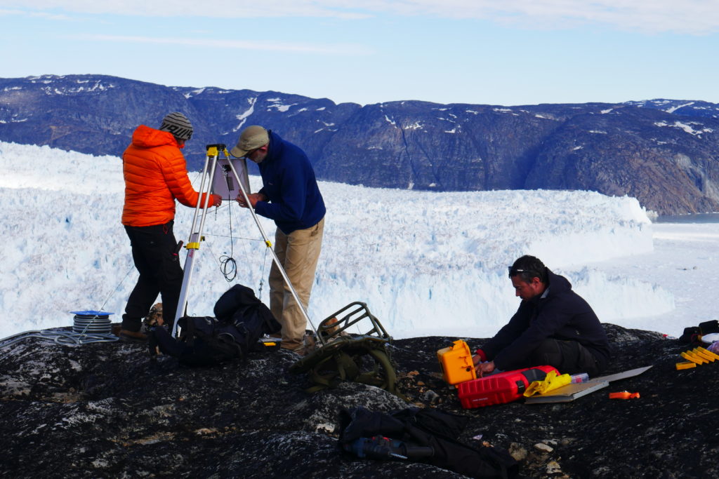 The team at work, unfazed by the stunning scenery surrounding them. Image: Tom Chudley
“That’s the bell from the Terra Nova” he explains..."Now we ring it for tea".
We reach Tom’s workstation and he shows me the complex maps and models he and the rest of the team are generating to try and better understand the Greenland Ice Sheet. Since the 1990s the ice loss from Greenland has accelerated dramatically, from contributing about 0.1mm/yr to sea level rise in 1993 (about 5% of total rise) to 0.85mm/yr in 2014 (about 25%). Importantly, as Tom explains to me, “this isn't just because of increased surface melt: about half of total mass loss comes from so-called dynamic losses. These result from an increased ice velocity that causes increased rates of iceberg calving at the marine margins of the ice sheet.” This iceberg production, which happens as the ice sheet breaks apart into fjords at the edges, is happening more and more often because the ice appears to be flowing faster. He shows me the UAV imagery and demonstrates how much more detail can be resolved compared to satellite images of the same ice sheets. Because the researchers are trying to understand the dynamics of the ice on hourly to daily timescales, they need continuous short term data – snapshots once every couple of weeks will not do the trick. “Our group uses a combination of satellite imagery, numerical modelling, and field observations” explains Tom, “including work with UAVs, time-lapse photography, research-grade GPS, borehole observations, ice-penetrating radar, and seismic measurements to better understand the processing occurring at the base of the Greenland Ice Sheet – processes that relate to these recent accelerations in sea level rise contributions.”
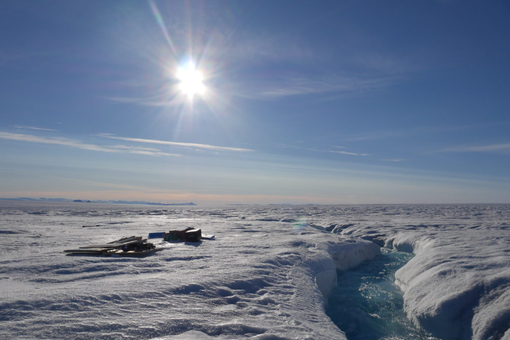 Relaxing under the summer sun by the riverside is every bit as possible on an ice sheet. Image: Tom Chudley
After Tom’s interesting explanations of what his group are trying to accomplish, I head back down again and have a last look around the exhibit. It provides a small window into the hard and adventurous work required to understand the dynamics of some of the more remote regions of our planet, and underscores the importance of understanding those processes for us all.
Seán Thór Herron is a third year undergraduate at Magdalene college, studying Earth Sciences, and served Issue Editor for BlueSci’s print issue 41.
Tom Chudley is a second year PhD student at Downing College, and a member of the Glaciology and Glacial Geology group at the Scott Polar Research Institute in Cambridge. Tom is funded by a studentship from the Natural Environment Research Council, and his group’s work in Greenland is part of the ERC-funded RESPONDER project.
The Uummannaq exhibition is open to the public at the Polar Museum on Lensfield Road, Cambridge, until the 22nd of December 2017 – perfect for a pre-Christmas outing!

 on the surrounding glaciers. BlueSci correspondent Seán Herron was lucky enough to receive a tour of the exhibition from Tom Chudley, one of the researchers who was in Greenland this year. He discusses the experience below, and explains why he thinks anyone who has the chance should go have a look!</em><br><br>It was a cold day, fittingly, as I cycled South and onto the Lensfield road to reach the Polar Museum. I locked my bike up, and entered the museum via its tall glass doors. I was met with a modern, neatly organised series of rooms full of what I assume is all sorts of polar paraphernalia, relating to Cambridge University’s long history of Arctic and Antarctic expeditions. The rooms are shock white and spartan, invoking images of cold, empty glaciers and vast plateaus waiting to be conquered.<br><br>Moving through to the back of the museum, I find the Uumannaq Exhibition. I meet Tom Chudley, a PhD student back from Greenland this summer who contributed to the exhibit, and he offers to show me around. The room shows the ongoing research on the Greenland Ice Sheet being carried out around the town of Uumannaq, in West Greenland. Also on display are photographs taken on an expedition of Swiss explorer and meteorologist Alfred de Quervain to the Uummannaq fjord and ice cap, providing insight on some of the history and culture of the region and its people.<br><br>Tom points up. Hanging overhead is a moderately sized winged aircraft. It’s a drone, Tom explains, or Unmanned Aerial Vehicle (UAV). They are launched over the ice sheet and piloted from the ground, using a combination of manned and automatic control. Tom takes me over to one of the exhibit’s displays, which shows how the UAV scans an area back and forth to take overlapping, high-detail images of the ice sheet. He shows me the glass case displaying the remote control for the drone, which is impressively large and technical looking. “It’s strange to see it behind glass after beating it up all summer”, he comments. Also in the case is a large, very durable looking glove. Do you need driving gloves to pilot a drone? As it turns out – sort of. Tom explains it is a falconry glove, which they wear to prevent the propeller of the drone injuring arms when it is hand-launched. The propeller spins several hundred times a minute!<br><br><div class='caption'><div id="attachment_1086" align="aligncenter" width="1024"><img class="size-large wp-image-1086" src="http://www.bluesci.co.uk/wp-content/uploads/2017/11/P1000439-1024x683.jpg" alt="" width="1024" height="683" /> The team at work, unfazed by the stunning scenery surrounding them. Image: Tom Chudley</div></div>Tom takes me upstairs to the research area of the building to show me some of what he is currently working on. On the way up the staircase, he points out a hardy looking old bell. “That’s the bell from the <em>Terra Nova</em>” he explains. The <em>Terra Nova</em> was the ship that carried Robert Falcon Scott to his famous (and final) expedition to be the first man to reach the south pole. “Now we ring it for tea”, Tom quips as we head upstairs.<br><br><blockquote>“That’s the bell from the <em>Terra Nova</em>” he explains..."Now we ring it for tea".</blockquote><br><br>We reach Tom’s workstation and he shows me the complex maps and models he and the rest of the team are generating to try and better understand the Greenland Ice Sheet. Since the 1990s the ice loss from Greenland has accelerated dramatically, from contributing about 0.1mm/yr to sea level rise in 1993 (about 5% of total rise) to 0.85mm/yr in 2014 (about 25%). Importantly, as Tom explains to me, “this isn't just because of increased surface melt: about half of total mass loss comes from so-called dynamic losses. These result from an increased ice velocity that causes increased rates of iceberg calving at the marine margins of the ice sheet.” This iceberg production, which happens as the ice sheet breaks apart into fjords at the edges, is happening more and more often because the ice appears to be flowing faster. He shows me the UAV imagery and demonstrates how much more detail can be resolved compared to satellite images of the same ice sheets. Because the researchers are trying to understand the dynamics of the ice on hourly to daily timescales, they need continuous short term data – snapshots once every couple of weeks will not do the trick. “Our group uses a combination of satellite imagery, numerical modelling, and field observations” explains Tom, “including work with UAVs, time-lapse photography, research-grade GPS, borehole observations, ice-penetrating radar, and seismic measurements to better understand the processing occurring at the base of the Greenland Ice Sheet – processes that relate to these recent accelerations in sea level rise contributions.”<br><br><div class='caption'><div id="attachment_1090" align="aligncenter" width="1024"><img class="size-large wp-image-1090" src="http://www.bluesci.co.uk/wp-content/uploads/2017/11/P1000589-1024x683.jpg" alt="" width="1024" height="683" /> Relaxing under the summer sun by the riverside is every bit as possible on an ice sheet. Image: Tom Chudley</div></div>Tom continues to take me through a lot of impressive looking layered and three dimensional maps of the ice sheets on the computer, and shows me the exciting dynamics of water drainage in the ice sheets. Lakes of meltwater on the surface can fracture the ice sheet and drain to the base of the ice, which can lead to increased ice velocities by a process known as ‘basal lubrication’ – literally lifting the ice sheet up in the process. To be able to assess this surface uplift, any surface maps need to be accurate on the order of 10 centimetres, which is a big part of what the groups’ UAV research is trying to accomplish.<br><br>After Tom’s interesting explanations of what his group are trying to accomplish, I head back down again and have a last look around the exhibit. It provides a small window into the hard and adventurous work required to understand the dynamics of some of the more remote regions of our planet, and underscores the importance of understanding those processes for us all.<br><br><em><a href="https://twitter.com/seanthorherron">Seán Thór Herron</a> is a third year undergraduate at Magdalene college, studying Earth Sciences, and served Issue Editor for BlueSci’s print issue 41.</em><br><br><a href="https://twitter.com/TomChudley"><em>Tom Chudley</em></a><em> is a second year PhD student at Downing College, and a member of the Glaciology and Glacial Geology group at the Scott Polar Research Institute in Cambridge. Tom is funded by a studentship from the Natural Environment Research Council, and his group’s work in Greenland is part of the </em><a href="https://www.erc-responder.eu/"><em>ERC-funded RESPONDER project</em></a><em>.</em><br><br><em>The Uummannaq exhibition is open to the public at </em><a href="https://www.spri.cam.ac.uk/museum/"><em>the Polar Museum</em></a><em> on Lensfield Road, Cambridge, until the 22<sup>nd</sup> of December 2017 – perfect for a pre-Christmas outing!</em><br><br>)