MONDAY, 20 AUGUST 2018
Imagine you need to go somewhere, but you have never been there before and there are no maps to show you how to get there. If you look at Google Maps on your phone, all you see is a few roads. So where would you start? Maybe you could ask around, find someone local to show you the way or give you directions. Ultimately you would have no way of knowing yourself, you would be stuck relying on local knowledge whose reliability you could not verify. Perhaps this is not such an issue, you might say, and to be expected in some parts of the world, even in this day and age. Now imagine you are a humanitarian aid worker, and you need to set up a famine relief station in a remote location that no one your organisation knows has ever been to before. The problem is now significantly larger.It is only when you stop and think that you realise how vital maps are to so many activities. In the UK, we are spoilt by a legacy of good quality, highly detailed maps produced by the Ordnance Survey for over two hundred years. We also have highly detailed maps from Google which include Street View functionality. But in other parts of the world, only very basic maps exist, if at all.
Open Street Map (OSM) was founded in 2004 by Steve Coast. It started with him building a map of his local area using a GPS unit and then sharing this map for free. Today it has grown into something much bigger: a global network of volunteer mappers. I spoke to Bjoern Hassler, a research associate at the Department of Education at Cambridge University whose work focuses on how open education resources can be used in schools in sub-Saharan Africa. Bjoern has also been involved in organizing and contributing to humanitarian mapping events since they came to Cambridge. He explained to me “Open Street Map is the Wikipedia of maps”. People all around the world are able to add to and edit the global map. This map is then available for everyone to use on an open license. The nature of the open license means that this mapping data can be distributed and used within other apps as long as the data is attributed to Open Street Map.
This freely available mapping data is invaluable for various humanitarian projects. Missing Maps is a consortium of several humanitarian organisations whose aim is to put the world’s most vulnerable people on the map. They use OSM as an infrastructure to help them plan and run projects. Specific tasks are created by the humanitarian organisations and added to a global task manager. Mappers can then log on and see what areas need mapping urgently.
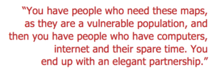
Projects that have been on Missing Maps include various malaria campaigns. Here, building numbers need to be known so that the right amount of insecticide can be provided to spray inside the buildings. More urgent mapping tasks may be required after natural disasters, such as earthquakes or flooding. I spoke to Morven Lavery, President for the Centre for Global Equality Student Society, which is supporting the Missing Maps project, about why she was so passionate to get involved with the project. “You have people who need these maps, as they are a vulnerable population,” says Morven, “and then you have people who have computers, internet and their spare time. You end up with an elegant partnership.”
While mappers can work individually, perhaps one of the best ways to get involved is through local “mapathons”. Steve Penson organized the first Missing Maps mapathon in Cambridge in May 2016, after being inspired by the ones run in London. Since then they have been steadily growing in size. Each month they take place at a new venue in Cambridge, held in locations as variable as the Scott Polar Research Institute and a beer garden. I went along to the Missing Maps November Mapathon at the Perse School in Cambridge to find out more.
Arriving at the school, I entered the hall where around fifty people were clustered in small groups ready with their laptops. I was welcomed by Bjoern and then set up my Missing Maps account. After a short introduction to bring the beginners - including me - up to speed, we were ready to start mapping. A couple of different tasks were suggested for beginners to have a go at. The first one involved marking buildings in Uganda. This involves scanning areas of satellite photos, then tracing over the area where you spot a building. This takes a bit of practice but the best tip I received from Bjoern was to look for the shadow of the building. During the event, I caught up with Steve Penson, who has been organising the Missing Maps events in Cambridge. He talked about how the events are a great way to volunteer your time, meet new people, plus the added bonus of pizza.
Throughout the evening there were also a couple of short talks on specific projects. Bjoern spoke about the project he is involved with in Ghana. The aim of the project is to map forty schools, which will then be used to plan how to implement Wi-Fi networks in these schools.
The second task I worked on involved tracing roads and buildings on top of satellite images. By the end of the evening I had made sixteen edits.
 Information that is proudly displayed in your Missing Maps online profile
along with the badges that you earn as you reach various mapping milestones. The sense that you are doing something meaningful here is well described by Morven. “When you are tracing the outlines of a building, it feels like for the first time somebody cares about these people”.
Information that is proudly displayed in your Missing Maps online profile
along with the badges that you earn as you reach various mapping milestones. The sense that you are doing something meaningful here is well described by Morven. “When you are tracing the outlines of a building, it feels like for the first time somebody cares about these people”.The mapping done by volunteers at Missing Maps mapathons literally puts new places on the map. These small edits and changes add up. On Missing Maps, over 13.5 million buildings have been added and nearly 1.5 million kilometres of road. This method of crowd-sourcing maps is highly effective. It is then taken a step further by local volunteers on the ground who tag important buildings on the map such as hospitals and schools, to begin to build a more complete and highly useful map.
The number of total edits on Open Street Map continues to increase, and new places are constantly being added. That said, there is always more that needs to be mapped. Whether that be due to physical changes in the landscape or environment after a natural disaster, or simply the construction of new buildings. Gradually it is getting easier for people to find each other.
If you are interested in getting involved in mapping yourself, you can go along to one of the regular mapathon events that are held in Cambridge or across the world. All you need as a beginner mapper is a laptop, a mouse and enthusiasm. People at the events are very welcoming and happy to teach you. Alternatively, you could download the “Mapswipe” app, which allows you to scan areas of satellite images and select those with features so that mappers know which areas to focus on. This prevents mappers from having to look at lots of images of rural areas where there are no buildings or roads.
Cara Louise Woods is a 3rd year student of the Biological Natural Sciences at Downing College. Images © OpenStreetMap
 was founded in 2004 by
Steve Coast. It started with him building a map of his local area using a GPS unit and then sharing this map for free. Today it has grown into something much bigger: a global network of volunteer mappers. I spoke to Bjoern Hassler,
a research associate at the Department of Education at Cambridge University whose work focuses on how open education resources can be used in schools in sub-Saharan Africa. Bjoern has also been involved in organizing and contributing to humanitarian mapping events since they came to Cambridge. He explained to me “Open Street Map is the Wikipedia of maps”. People all around the world are able to add to and edit the global map. This map is then available for everyone to use on an open license. The nature of the open license means that this mapping data can be distributed and used within other apps as long as the data is attributed to Open Street Map.<br><br>This freely available mapping data is invaluable for various humanitarian projects. Missing Maps is a consortium of several humanitarian organisations whose aim is to put the world’s most vulnerable people on the map. They use OSM as an infrastructure to help them plan and run projects. Specific tasks are created by the humanitarian organisations and added to a global task manager. Mappers can then log on and see what areas need mapping urgently.<br><br>Projects that have been on Missing Maps include
various malaria campaigns. Here, building numbers need
to be known so that the right amount of insecticide can
be provided to spray inside the buildings. More urgent mapping tasks may be required after natural disasters, such as earthquakes or flooding. I spoke to Morven Lavery, President for the Centre for Global Equality Student Society, which is supporting the Missing Maps project, about why she was so passionate to get involved with the project. “You have people who need these maps, as they are a vulnerable population,” says Morven, “and then you have people who have computers, internet and their spare time. You end up with an elegant partnership.”<br><br>While mappers can work individually, perhaps one of
the best ways to get involved is through local “mapathons”. Steve Penson organized the first Missing Maps mapathon
in Cambridge in May 2016, after being inspired by the
ones run in London. Since then they have been steadily growing in size. Each month they take place at a new venue in Cambridge, held in locations as variable as the Scott Polar Research Institute and a beer garden. I went along to the Missing Maps November Mapathon at the Perse School in Cambridge to find out more.<br><br>Arriving at the school, I entered the hall where around fifty people were clustered in small groups ready with their laptops. I was welcomed by Bjoern and then set up my Missing Maps account. After a short introduction to bring the beginners - including me - up to speed, we were ready to start mapping. A couple of different tasks were suggested for beginners to have a go at. The first one involved marking buildings in Uganda. This involves scanning areas of satellite photos, then tracing over the area where you spot a building. This takes a bit of practice but the best tip I received from Bjoern was to look for the shadow of the building. During the event, I caught up with Steve Penson, who has been organising the Missing Maps events in Cambridge. He talked about how the events are a great way to volunteer your time, meet new people, plus the added bonus of pizza.<br><br>Throughout the evening there were also a couple of short talks on specific projects. Bjoern spoke about the project he is involved with in Ghana. The aim of the project is to map forty schools, which will then be used to plan how to implement Wi-Fi networks in these schools.<br><br>The second task I worked on involved tracing roads
and buildings on top of satellite images. By the end of
the evening I had made sixteen edits. <strong><img class="alignright wp-image-1502 size-medium" src="http://www.bluesci.co.uk/wp-content/uploads/2018/08/Screen-Shot-2018-08-16-at-11.01.37-300x106.png" alt="" width="300" height="106" /></strong>Information that is proudly displayed in your Missing Maps online profile
along with the badges that you earn as you reach various mapping milestones. The sense that you are doing something meaningful here is well described by Morven. “When you are tracing the outlines of a building, it feels like for the first time somebody cares about these people”.<b></b><br><br>The mapping done by volunteers at Missing Maps mapathons literally puts new places on the map. These small edits and changes add up. On Missing Maps, over 13.5 million buildings have been added and nearly 1.5 million kilometres of road. This method of crowd-sourcing maps
is highly effective. It is then taken a step further by local volunteers on the ground who tag important buildings on the map such as hospitals and schools, to begin to build a more complete and highly useful map.<br><br>The number of total edits on Open Street Map continues to increase, and new places are constantly being added. That said, there is always more that needs to be mapped. Whether that be due to physical changes in the landscape or environment after a natural disaster, or simply the construction of new buildings. Gradually it is getting easier for people to find each other.<br><br>If you are interested in getting involved in mapping yourself, you can go along to one of the regular mapathon events that are held in Cambridge or across the world. All you need as a beginner mapper is a laptop, a mouse and enthusiasm. People at the events are very welcoming and happy to teach you. Alternatively, you could download the “Mapswipe” app, which allows you to scan areas of satellite images and select those with features so that mappers know which areas to focus on. This prevents mappers from having to look at lots of images of rural areas where there are no buildings or roads.<br><br><em>Cara Louise Woods is a 3rd year student of the Biological Natural Sciences at Downing College. Images © OpenStreetMap </em>)